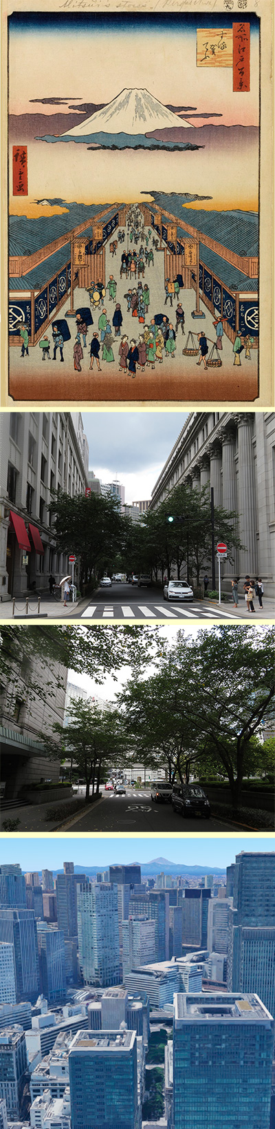
I visited one of my favorite places, One Hundred Famous Views of Edo, drawn by Hiroshige Ando, and what the scene is like now.
First of all, the first spring part "Edoyukibare". Uukibare means a sunny day with snow. If you guess the point you are looking at, it seems that it is in the sky on the way from the intersection of Edobashi Kita to Nihonbashi Kitazume.
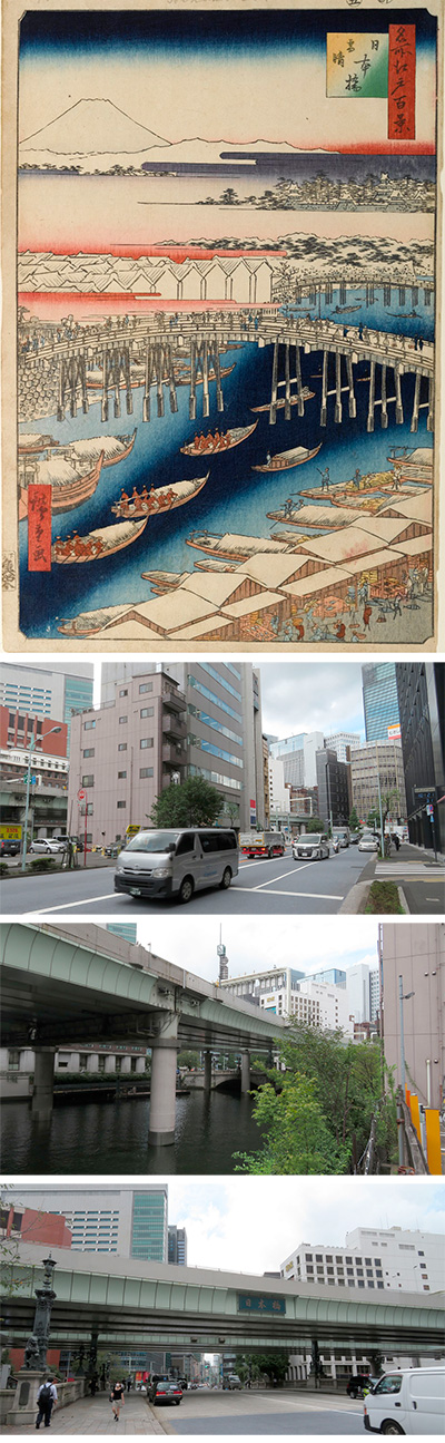
It is said that Hiroshige Ando painted this painting in May 1856, 3rd year of Ansei. Nihonbashi seems to have already become the center of Edo, and it is said that many merchant houses, warehouses, and wholesalers were lined up on both sides of the current Chuo-dori and Nihonbashi.If you look at the picture in detail by dividing it into three parts, the lower part of the picture shows the fish bank of Nihonbashi with snow on the roof, and you can see people unloading and carrying fish with a balancing pole. You can see it. It seems that seafood arrived every day along the coast of Nihonbashi at that time and played the role of a port, a market, and a warehouse. Is there any difference in the fact that people on land wear dark blue costumes, and people rowing high-speed boats called Oshiokuribune wear red costumes? The boats that cross the river are hung with sardines to protect the fish, which is a product, from snow.
In the middle row, a group of Daimyo-like Sankin-kotai crosses over Nihonbashi, which is said to have been about 50 meters at that time. It is said that "Edo departs at 4 o'clock", so the time is probably set around 4 o'clock in the morning. You can also see fishmongers carrying balance poles and large eight cars. On the left side of the bridge, you can also see the Kosatsu hall, which served as a bulletin board in the Edo period. It seems that there was also a "bleaching place" that exposes the people who violated this Kosatsu to the eyes of the general public. The bridge on the right side of the white Kurayashiki is Ichikoku Bridge, which is still located under the Metropolitan Expressway on Sotobori Dori.
Edo Castle surrounded by trees is drawn in the lower right of the upper row, Tanzawa is drawn over the haze of the sunrise, and Mt. Fuji with snow is drawn beyond it. Although it is exaggerated considerably, Mt. Fuji may have been seen from Nihonbashi at that time with such an image.
Actually, the viewpoint is quite high, so first I decided the viewpoint roughly according to this picture and relied on Google Earth. We will approach the destination with the west side facing up.
Mt. Fuji depicted is covered with snow, but on Google it is a summer mountain. The building is also unrealistic, so I looked at the street view of Google Map from the same point. Currently, Nihonbashi is under the Metropolitan Expressway, so I can't see it at all. I also looked at Apple Map Street View. This one has a slightly lower angle. It's a deformed picture, so I forcibly put it on the photo.
From here, I went to the actual point. This view from the sky is probably the point of view of the picture. The area around the parking lot on the left is the coast of the Nihonbashi River, where the riverbank would have been at that time. The signal you can see is Nihonbashi Kitazume, that is, the north side of Nihonbashi, which is not visible in the picture. The bridge is under the Metropolitan Expressway, which you can see a little on the left side. The black building on the right is Suruga Bank, and the first floor is now Starbucks. Next to the parking lot on the left is Nomura Securities Headquarters, and the area is Kabutocho.
This photo is Nihonbashi seen from the old Nihonbashi riverbank. Unfortunately, it is under the highway, but in the Edo period, you should have been able to see Mt. Fuji from here. The white building is now the headquarters of Kanzume's Kokubu, and the left side of it is the headquarters of Eitaro, who is famous for Anmitsu.
This is a photo of the direction of Ginza in front of the current Nihonbashi. It's painful that the highway is completely covered. Last year, only the bottom was made of stone.
This is the Kirin statue with wings standing in the center of Nihonbashi, which became a novel. The reddish-brown building on the left is Nomura Securities, the glass-walled building behind is Nishikawa Nihonbashi, behind it is Coredo Nihonbashi, and beyond that is Nihonbashi Tower.
All roads lead to Nihonbashi. A road marker is embedded beside this bridge to mark the beginning of Japanese roads. Behind the photo is the new building of Mitsukoshi Department Store.
This is an image of Hiroshige's perspective of Nihonbashi, which he would have drawn by going back to the beginning. Eventually it will be the intersection of Edobashi.
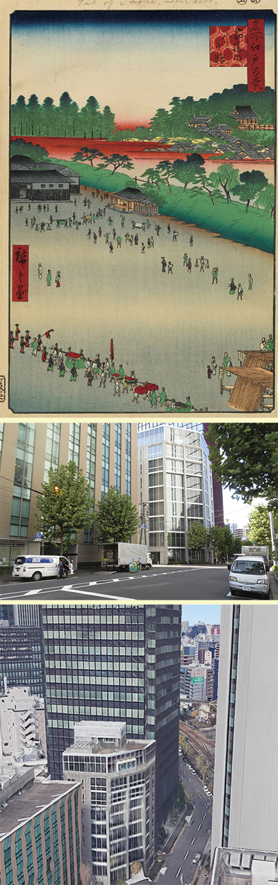
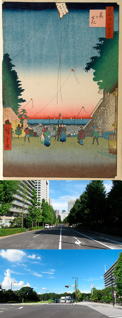 002 is Kasumigaseki. It is the scenery of the New Year from the intersection on the current Roppongi Dori, Ministry of Foreign Affairs. A long time ago, the Oshu Highway passed through this plateau, and a barrier was set up to subdue Yamato Takeru's Ezo. It seems that it came to be called.
Most of the paintings are concentrated in the lower half. The right side of the picture is the upper residence of the Matsudaira Mino Mamoru and the Kuroda clan of the Fukuoka clan, which is currently the government building of the Ministry of Foreign Affairs, while the right side is the upper residence of the Matsudaira Akimori and the Asano clan of the Hiroshima clan, and the current government building of the Ministry of Land, Infrastructure, Transport and Tourism.
Beyond the people on the slope, you can see the densely packed townhouses, the roof of Tsukiji Hongwanji Temple, and the sea of Edo Bay. On the right side of the picture is a large kadomatsu, and next to it is a person carrying luggage. It is said that this person is a person who buys a fan box that is no longer needed after the New Year and sells it again next year. At that time, people used to carry the lucky charm Suehiro in a fan box when they went to the New Year holidays, so to speak, it's a recycling shop dedicated to fan boxes.
On the left is a parent and child with a battledore, and from the bottom of the slope, a samurai is trying to form a line and go up the slope. To the left is a group of Daikagura holding money. People who dance the lion dance, which is believed to have the power to dispel plagues and evil spirits, on New Year's Day. On the left, the duo facing to the right are Hurray Tayu and Saizo. It is said that on New Year's Day, these two people became a group, dressed as a toshigami, and became a god's yorishiro himself, giving blessings to each house and walking. The person who carries the weight on his shoulder to the left is "Kohada Sushi Sales". He seems to be a person who sells the sushi that is the basis of "Kohada's Awazuke", which is still on the Japanese New Year menu.
At the top of the picture, the kite of Uoei, the publisher, is flying, is it Hiroshige's fashion? Hiroshige's ukiyo-e often feature kites and nobori with the theme of this fish.
Now, let's take a look at Google Earth with the east-southeast facing up. The upper left of the picture is the Ministry of Land, Infrastructure, Transport and Tourism, the right is the Ministry of Foreign Affairs, across Roppongi Dori, and the lower is the Kensei Memorial Park. It's a place where I often shoot TV dramas, "Aibo".
Next, let's look at the map. From Kasumigaseki, it seems that it looked almost east-southeast. At that time, there should be nothing other than Tsukuda Island beyond the Sumida River, so it must have been the sea.
If you look at this on a 3D map with the viewing direction facing up, you can get an overview.
Well, now I actually went to see what's going on here. The slope is not as steep as the picture, but the Ministry of Land, Infrastructure, Transport and Tourism is on the left and the Ministry of Foreign Affairs is on the right, and it seems that you saw the direction of the sea from here. However, now the front is the Ministry of Agriculture, Forestry and Fisheries, the right is the high-rise general government building No. 5 where the Ministry of the Environment and the Ministry of Health, Labor and Welfare are located, and the brown building on the left is the new tower of the Imperial Hotel. I can't see the sea at all.
If you overlay the picture drawn by Hiroshige on this, it will look like this. I shortened the current photo a little more to fit the picture.
Looking to the right from Hiroshige's point of view, in the direction of Roppongi, you can see Intercity Akasaka on the side of the Tameike intersection at the entrance of Kasumigaseki on the Metropolitan Expressway.
If you look to the right, you can see the Ministry of Land, Infrastructure, Transport and Tourism's government building and the Imperial Palace Forest on your right. The slope beyond that is Miyakezaka.
Just behind the viewpoint is the Kensei Memorial Park.
The image looks clockwise and counterclockwise from the viewpoint on the slope.
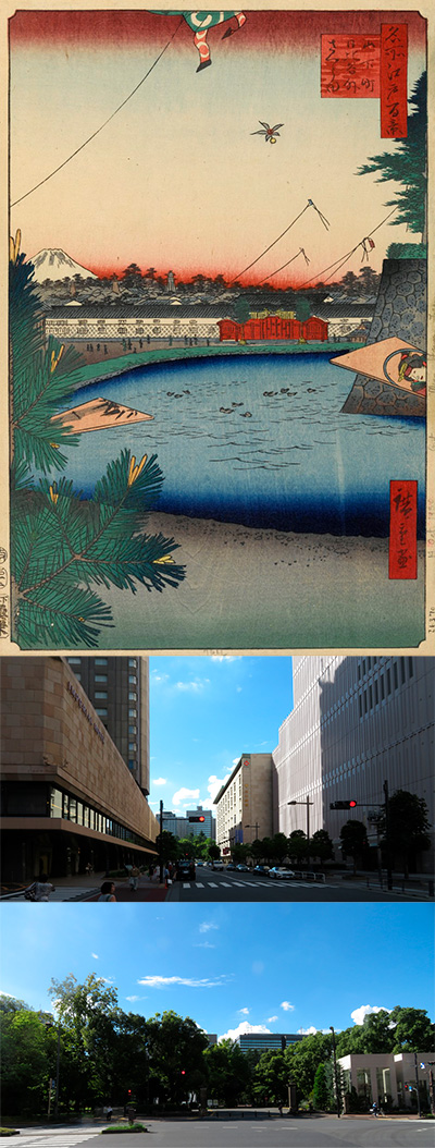
003 is Sakurada outside Hibiya, Yamashita-cho. It seems that the picture is from the current Taimei Elementary School on Miyuki-dori, around 5-chome, Ginza, Chuo-ku, looking toward Hibiya Park.
Under the current Metropolitan Expressway, the road between the Imperial Hotel and the Takarazuka Theater, Miyuki Dori is also a moat, and it seems that it was just like a moat's junction. It is a picture of the west-northwest seen through the moat.At the bottom of the picture is a battledore with a large tradesman Kadomatsu on the left and a bamboo picture behind it. Is Shochiku producing the happy New Year? The battledore with the strangely realistic actor picture on the right side is also drawn large, so it can be imagined that the battledore on the road in front is a hanetsuki called "Oibane".
Looking at the middle part of the picture, the point you are looking at is Yamashita-cho, a town of tradesmen, but on the other side of the picture is a samurai mansion town where daimyo mansions stand. Beyond the duck in the moat, many people go to the mansion for New Year's greetings.
The land of the mansion that you can see is the land that was created by reclaiming the inlet of Hibiya since the Edo period, and was called Hibiya. Inside the stone wall on the right, there was the Kasama Domain Makino Etchu no Kami's upper mansion, and although it was hidden behind it, there was Hibiya Gomon and Sakurada Gomon beyond it. The outside, around Atago, was called Soto Sakurada. In both areas, there are the largest number of samurai residences in Edo, and most of them seem to have been Tozama Daimyo, whose land is a little small. Therefore, there are many fire lookout towers in the painting.
The red gate on the front and the long wall of the Namako wall are the upper residences of Matsudaira Hizen no Kami in Hizen Saga. It is said that the reason why there are fine guards on both sides of the gate is that the feudal lord has a high prestige. It seems that it was a famous mansion to put a pine decoration, which is a drum body made of rice straw, on the gate.
One kite hangs down in the upper right corner of the mansion, which is a kite that the children of the daimyo mansion lost in a kite battle called "Karamekko".
At the top of the upper part of the picture, the tradesman's kite is cut off. It is ironic that the kites that the townspeople, who are usually oppressed by the samurai, are flying are much higher than the samurai residences. The fact that the wings of the hanetsuki are small and flying in the middle is also Hiroshige's concern.
I went to the viewpoint of the current picture, but I can't see it at all because the JR guard and the Metropolitan Expressway are in the way. So I decided to go beyond the guard. That is this image. In fact, I've modified the photo perspective to straighten the building.
What is different from Hiroshige's painting is that this is already on the moat.
The left is the former Abe Harima no Kami's upper residence, the current Imperial Hotel, and the right is the former Makino Edo Hantei's upper residence, the current Tokyo Takarazuka Theater, and the Nissay Theater. And the front is the upper residence of Matsudaira Hizen no Kami in Hizen Saga, now Hibiya Park. It seems that there was a moat under this road, Miyuki Street.
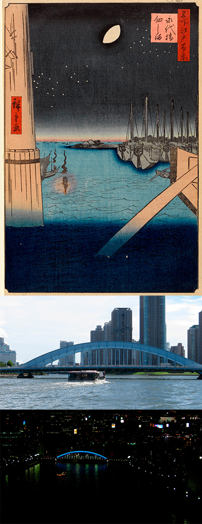 This Eitai Bridge is a bridge built between Hakozaki Town and Fukagawa Saga Town in 1698 to celebrate the birth of the 50th Shogun Tsunayoshi. Three years later, it is reported that after the Ronin Ako slaughtered at Kira's residence in the neighborhood of both countries, he crossed this bridge for a report and headed for Sengakuji Temple, where his master, Asano Takumi nokami, sleeps. I am. In the 4th year of culture (1807), there is a record that a spectator who tried to go to the festival of Fukagawa Hachiman tried to cross this bridge at once, and the bridge collapsed, causing more than 1,500 casualties. This picture was drawn in Ansei 4 (1857), so the model bridge will be a bridge of several generations.
In the upper part of the picture, the pier of Eitai Bridge is on the left side, the white moon of the 13th night is in the middle, and the stars are studded under it.
In the middle, you can see that the left pier looks like hardware and is reinforced. Hiding in the shadow, a white fish fishing boat is burning a bonfire. Four-handed nets are drawn as fishing gear, but in this area, people called white fish officials were actually allowed to fish white fish, and the method seems to be mainly construction nets, and in fact It is pointed out that it is different.
In any case, white fish fishing is the fishing season from November to March, and in Edo around this time, it seems that the swaying bonfire at night was a tradition that heralded spring.
In Kabuki's popular performance at the time, "Sannin Kichisa Kuruwa no Hatsugai," a thief who pushed Yataka into the river and robbed 100 cars at the Okawabata at the foot of this bridge. There is a famous line that everyone at that time knew, "The moon is also hazy, the white fish is also hazy, and the spring sky" is spit out by Ojo-Kichisa.
Tsukuda Island is drawn in the back of the picture, and many boats, probably Tsukuda Island fishermen, are drawn on the left. On the right side, there are many large ships called Bensai ships. Actually, on the right bank side of the bridge, there are only Okawabata city and Matsudaira Echizen nokami's mansion, so bring the Bensai ship moored at Edo Minato beyond that and balance it as a picture. It seems that I took it.
 I actually visited one of my favorite places, One Hundred Famous Views of Edo, drawn by Hiroshige Ando, and what the scene is like now.
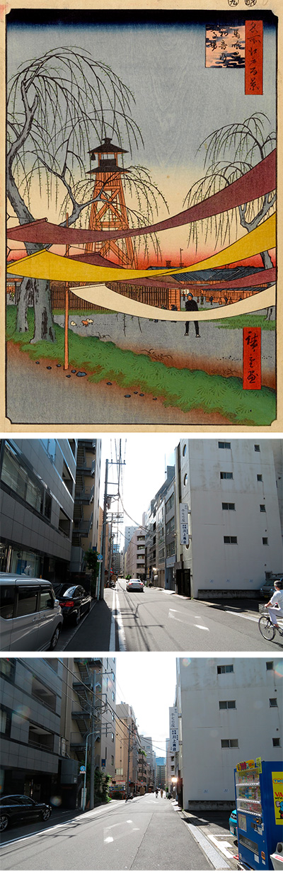
It is said that Hatsune no Baba Riding Grounds in Bakuro-cho in 006 was drawn just after going up Bakurocho Station on the JR Sobu Line. At the end of the current Edo-dori, that is, an alley on the northwest side of Mito Kaido, there is the southern end of Hatsune's Baba, and it looks like a picture of Nihonbashi from there. According to the book "Picture Book Edo Souvenirs", there is a horse field on the side streets of 2-chome and 3-chome, Bakurocho, and there are several willows on the edge, and the fire lookout tower can be seen first, and there is a description that he was practicing equestrian.
This Baba is said to be the place where Ieyasu Tokugawa started the battle of Sekigahara and had his horses aligned, and it is said that it was the oldest Baba in Edo. Hatsune Inari was sitting right next to it, so it was called Hatsune no Baba after that. In Baba, a mainland base was built in the center in a horse-spinning style, and it seems that horses could run around it. It seems that this neighborhood has come to be called Bakurocho because the livestock dealer, Genbei Takagi, who manages the horses here, was the head of the horse.
This painting is at the southern end of Baba, and on the north side of it, there is a Gundai mansion, which is under the direct control of the Shogunate and the civil affairs of Kanhasshu (currently around Tokyo and the six prefectures). Kanto Gundai was also in charge of what is now called administration, trial, tax collection, and police authority. Even now, there is a sign for "Gundai Yashiki Ruins" next to the Higashi Nihonbashi police box.
When a problem occurs in the area under the direct control of the shogunate, the farmers and other parties must come to this point to solve the problem, and there is an accommodation facility called a public inn (kujiyado) in this area where such people stay. There were many. It is said that the rent was officially 248 Mon (equivalent to 6,200 yen in modern times) without a bath, eating at the dining room at a fixed time in the morning and evening with half board. There were quite a few public inn (kujiyado) in Bakurocho, each of which formed a group of friends and was given exclusive business rights. In addition, it seems that there were also people who were engaged in business such as current lawyers, judicial scriveners, and amanuensis.
The turret in the picture is a fire lookout tower in the town where only a half bell is hung. This was a turret that stood one kilometer at a time, and the guard who discovered the fire in the town immediately rang a half bell, convened a fire extinguisher, and notified the townspeople of the outbreak of the fire. The half-bell near the fire site rang in rapid succession to inform that it was the source of the fire, and when the fire was extinguished, two points were hit repeatedly, and this two-point hit was called "Ojan". There seems to be a theory that, in turn, everything that has come up to now is wasted, and it has come to be called "It is just Jan."
In the picture, although it is Baba(practicing equestrian), there are 4 dyed items dried, but it is said that it is from Kohya-cho, which went west from here. This neighborhood is still prospering as a textile wholesaler town. In addition, you can see puppies playing and people who look like housewives carrying children talking to each other. At that time, it seems that horse training was only in the morning, but more than that, Hiroshige might have tried to draw a peaceful and peaceful scenery as the samurai moved away from the war.
I searched for the place from the old map. The green part is Baba, and the white part above it is Gundai Mansion. I put a red gradation, which is the viewpoint, on it. I also put a modern map on it. With this, you can understand the general positional relationship.
I went to the actual place. On the right side of the photo, the parking lot seems to hit the southern end of Baba. Surrounded by buildings, I can't see anything.
If you go out to Edo-dori, which is one road away, the road is brilliantly expanded. This is a photo of the Asakusabashi side and the Nihonbashi side.
I put Hiroshige's picture on the viewpoint and left only the dyed ones. The place of this picture now is a picture that makes you laugh a little, as you can only see the walls of the building.
 I actually visited one of my favorite places, One Hundred Famous Views of Edo, drawn by Hiroshige Ando, and what the scene is like now.
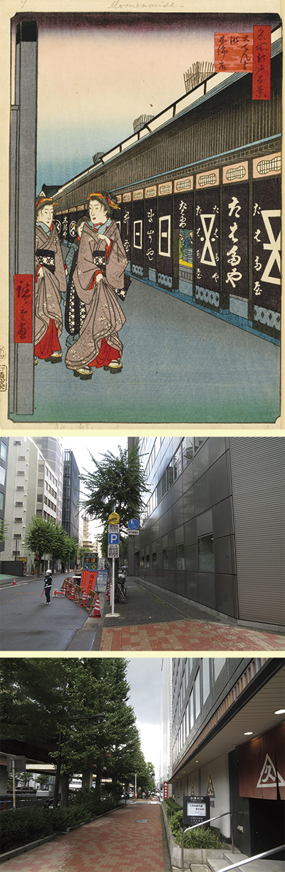
The Otenmacho cotton shop in 007 looks like a picture seen from the side of the Ozu Washi building on Showa-dori, 2-chome, Nihonbashi-honcho. On the road in Honcho that runs through Nihonbashi from east to west, there were many cotton wholesalers, and it was commonly called the cotton shop (Momendana). Initially, this street was the Oshu Kaido, the main street from the center of Edo to the Tohoku region. The Oshu Kaido passed through Honcho, Odenmacho, and Hatagomachi, left Asakusa Gomon, went north, and crossed the Sumida River at Hashiba. The first post station was Odenmacho, and many Denma were prepared. Denma is a horse for transportation prepared at each post station, and it is easy to understand the image that many trucks were prepared in the modern terminal.
This town, along with Kodenmacho on the north side and Minamidenmacho on the Kyobashi side, was called Sandenmacho, and was a town that played the role of a horseman who was obliged to transport luggage for official use by the Shogunate. It is said that the name of the town is also derived from the mansion of Magome Kageyu, who plays the role of Denma. Mr. Magome is from Mikawa, and his subordinates seem to have been doing something like an agency for Mikawa cotton as a side business.
So this time, please start with the old map.
Let's add a red gradation to the point of view.
I also overlaid a modern Apple map.
I also overlaid aerial photographs.
Eventually, in the 2nd year of Keicho (1597), the Senju Ohashi Bridge was built over the Sumida River, and the first post station on the Oshu Kaido became Senju, which changed the direction of this town. Around the time of Kanei (1624-44), some of the elderly people in the town and those who were in charge of horse riding events began to handle cotton, and after that, the town was transported while repeating its rise and fall. I've taken a big break from my work. Many cotton wholesalers from Ise lived in Odenma-cho, and they handled the highest quality cotton from Ise Matsusaka. Eventually, during the Kyoho era (1716-35), in addition to cotton-producing areas such as Mikawa, Ise, and Owari, kimono stores and other stores were also opening stores one after another, and this neighborhood was Edo Ichino. It has become a cotton town.
At both the Sanno Festival and the Kanda Myojin Festival, which are held every other year in Edo, the leading float, "Kankodori," was put out from this town. It is an episode that talks about the richness of wealth in Odenmacho.
The once prosperous cotton store now remains as a textile wholesale district around Nihonbashi Yokoyamacho, which is about 2 km further along the Oshu Kaido.
Let's take a closer look at the picture.
The night view of the cotton stores from Kido, is it just before the stores close? Since the door is open, it is said that it may be before 10 o'clock at the latest. Many of the cotton wholesalers at that time had a majestic black plastered stance, and it is unique to Odenmacho that shops of the same construction are lined up under one roof. On the second floor of the building, the lattice can be removed from the inside in case of emergency, a fire-prevention rainwater tank is surrounded by a cage on the roof, and the boundary between the stores is Udatsu. It seems that he was paying particular attention to fire prevention measures by placing a fire wall like this.
Looking at the Noren, the store continues from the right to Tabataya, Masuya, and Shimaya, and in reality, the composition is such that there are even more stores. Inside the store, cloths are piled up, and it is depicted that they are still doing business. The largest Tabata shop is the Edo branch of Tanaka shop in Ise Tsu, and the clerk is said to have been a "man-only shop" dispatched from the local area.
Two geisha are drawn on the left. One of them is a nostalgic man and has a collar of underwear called Nagajuban, so is he getting sick or is it still cold at this time? In addition, the geisha don't wear socks, so it may have been colder. Both of them are wearing plain clothes, and the style of hanging obi is popular these days.
In addition, it is said that this picture was drawn in the 5th year of Ansei, and it is the last work in this famous Edo Hyakukei series. At that time, after the Tenpo Reforms, which prohibits luxury, there are no more shops that only sell cotton wholesalers, so the actual store structure is a little different. It seems that some researchers think that Hiroshige may be an advertising picture drawn by a cotton wholesaler to attract customers.
Well, I asked him what was going on there now. It was a town with a completely different image of buildings standing in a forest, just as the construction was being done. The road in front of you changed from Oshu Kaido to Kyu-Nikko Kaido, and is now called Odenma Honcho Dori.
From the point of view, this is the view from the right, Showa-dori, and the Edobashi intersection. The left corner is the Itochu Kenzai Headquarters Building, where aluminum plates are neatly pasted.
From the viewpoint, this is the view from the left, Showa-dori, and Iwamotocho. The right side is the Ozu Washi Main Building. Two lines ahead is Edo-dori (Mito Kaido), and the JR Sobu Main Line is now running underground.
This is a video taken counterclockwise from Hiroshige's point of view. First of all, the main building of Ozu Washi and Showa-dori, and above that is the Metropolitan Expressway Ueno Line, both of which have considerable traffic volume.
The underpass that crosses the Nihonbashi side and the left is the Itochu Kenzai Headquarters Building.
This is a photograph mainly taken of the wall of the Itochu Kenzai Headquarters building to match the perspective of the picture drawn by Hiroshige.
I overlaid the picture drawn by Hiroshige on it.
In addition, I cut out Kido and the geisha and collaged the current photos.
You might be surprised if Hiroshige sees such a picture.
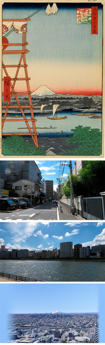
 The 008 Sugacho is a view of the Bank of Japan from the intersection of Mitsukoshimae Station on the current Ginza Line, Muromachi 2-chome. Currently, the building on the right is the Mitsui Main Building, which houses Sumitomo Mitsui Trust Bank and Sumitomo Mitsui Banking Corporation, and the building on the left is the Mitsukoshi Department Store Nihonbashi Store. The street between the two buildings is now called Edo Sakuradori, and it is a one-way street from the other side to this place. The lower part of the picture, the wide street on the left and right, is the current central street.
When Ieyasu Tokugawa came to Edo and built a town, it seems that he designed it so that Edo Castle and Mt. Fuji could be seen from the road that runs from the northeast to the southwest of this area. In particular, this road was called Suruga-cho because Mt. Fuji can be seen in front of it and Ieyasu first settled the servants he brought from Suruga. Actually, you can't see Mt. Fuji at the size like this picture, but it seems that you could definitely see Mt. Fuji.
Let's take a closer look at the picture.
Both the left and right stores were Echigoya (currently Mitsukoshi) at that time, but the left side is a store that sells thick cloth (futomono) other than silk, and the right side is a silk specialty store. was. On the left side of the picture, the person walking with a large dark blue baggage on his back seems to be a foreigner, and he is going to go to his customer with a thick item on his back.
Furthermore, in order to show that the entire town of Surugamachi is Echigoya and is very busy, this picture depicts people with various profiles in a one-point-focused perspective composition. Because the fish bank of Nihonbashi is near, a fish hawker carrying a balance pole, a group of maids and samurai who work at Edo Castle, a slightly higher samurai, a stealth samurai, a traveler, a soba hawker, a child of an apprentice servant etc.
Judging from these factors, it seems that this picture was also drawn for the promotion of Echigoya. It is said that this painting was published around the winter solstice of Ansei 2 (1855). In October, there was a big earthquake in Ansei, and Echigoya was forced to suffer great damage, but by the beginning of the following year, its sales have recovered. It is presumed that the drawing of this bustle in the popular series One Hundred Famous Views of Edo contributed greatly to the reconstruction. It means that it has become an advertisement for the winter bargain sale.
So, I checked this Echigoya, that is, Mitsukoshi now.
The founder, Takatoshi Mitsui, was born as the fourth son of the Mitsui family, a wealthy merchant in Matsusaka. At the age of 14, my mother handed me a million yen worth of cotton, and I got a job as an apprentice at a kimono shop run by my eldest brother in Edo. After that, he went up to the top, but his eldest brother dismissed his rare business talent and he was returned to his hometown of Matsusaka. At that time, it is said that the first 1 million yen was 16.6 million yen.
Eventually, his eldest brother died, and Takatoshi, who received permission from his mother, returned to Edo in 1673 at the age of 52 and set up a store in Nihonbashi-honcho. Therefore, we will stop the credit sales that both customers and kimono stores have been suffering from until then, and switch to cash fixed price sales. At that time, it was common sense in Edo's commercial transactions that goods were received first and payments were made at a later date. Nowadays, the ordinary cash fixed price sale is very popular with the common people of Edo, and Echigoya will develop into the best shop in Edo. However, although this system suffered considerable harassment from the same traders, it happened to be hit by a fire ten years later, and it will open a new store in the current Suruga-cho.
This Hiroshige painting is about 60 years after the death of his ancestor Mitsui Takatoshi, but after that, the store on the left side of the painting developed as Mitsukoshi, Japan's first department store, and the store on the right side eventually developed. , Became a money changer, undertook the exchange method of the Shogunate, supported the Meiji government after that, and developed as a Mitsui Zaibatsu enough to lay the foundation of this country.
Well, I went to see what the place is now. First, check the location on the old map of the early Meiji era, a few years after this painting was drawn. I put a red gradation in the place that becomes the viewpoint. It is a modern map that is roughly scaled and aligned with this. In the same way, I added a red gradation of the viewpoint.
When I actually went there, Mitsukoshi Department Store Nihonbashi Main Store and Sumitomo Mitsui Banking Corporation still remain in that position.
However, this does not match the angle drawn by Hiroshige, so I tried using Google Earth. You can see that Mt. Fuji is actually seen in this direction.
Go a little closer and get closer to the angle of Hiroshige's painting. The buildings on the left and right are Coredo Muromachi.
I will overlay Hiroshige's picture on this.
I will pull out the cityscape and insert the current photo.
Mt. Fuji doesn't actually look so big, but I left only the haze and tried to fit Mt. Fuji around the time of the first snow of this year.
Even so, I couldn't deny the feeling of strangeness, so I transformed the low-angle image and matched the colors to fit it.
Among the famous Edo 100 views drawn by Hiroshige, this is a rare case where the drawn material remains almost as it is.
 I actually visited my favorite one hundred views of Edo drawn by Hiroshige Ando and what the scene is like now.
Yatsukoji in the brace of 009 is a bird's-eye view of Kanda Myojin and Yushima Shrine from the sky above the old Nakasendo on the north side of the current Yasukuni Dori and Chuo Dori Sudacho intersection. ..
This is the place where the gate of Kanda Mitsuke was located inside the north of the outer shell of Edo Castle, and the shogunate created a plaza here as a fire protection area to prevent the spread of fire. Here, the road from Nihonbashi and the road from Hongo and Shimotani to Kanda intersected, so I called it "bracing". Actually, there were more than 10 highways such as Ou Kaido, Nikko Kaido, Nakasendo, and Koshu Kaido, but they were called "Yatsukoji". In this case, "eight" is used not to mean eight roads, but to mean many.
Therefore, the title of this picture is "Inside Sujichigai Gate at Yatsukoji".
Let's take a closer look at the picture.
On the upper and right sides of the picture, a hexagonal pattern is used in the shape of colored paper, which seems to be a feature of the first printing of this Edo 100 series. Below that, the total guardian of Edo, Kanda Myojin, is drawn. Seen from Edo Castle, it is exactly the position of the Kitaonimon. To the left is the forest of Shoheizaka Gakumonsho. This is an educational institution under the direct control of the shogunate, also known as "Shoheikou". It is now Yushima Seido.
Below the red Genji cloud is the Kanda River, but around this time, the shogunate, which was stimulated by the arrival of foreign ships and the modern armament of the great powers, established a martial arts training institution called Kobusho. I made it around here. Therefore, it is said that Hiroshige, who avoided pointing out from the Shogunate, intentionally blurred its existence.
In the middle, the Kanda River is beyond the green bank where willows and pine trees are planted. On the left, you can see that the Tsujibansho, which was guarding the eight alleys, is lit. It is said that the eight alleys at that time were busy and the bansho was open even at night. There is a Kido behind it, and if you go to the right, you can cross the Shohei Bridge and go to Shoheizaka Gakumonsho and Kanda Myojin. The tip of Kanda Myojin is Nakasendo, which leads to the current Hongo Sanchome.
Hiroshige seems to have drawn a lot of people such as samurai, carpenters, apprentices, and peddlers of balance poles on the eight alleys, but the white areas are also left to show the size of this place. In particular, in Kanda Tacho on the left side of the screen of this eight alley, greenery dealers have been gathering since the early 17th century (Keicho era), so the balance pole may be a vegetable peddler.
To the right of the bottom of the screen, there is a streak gate, although it is not drawn. To the left of it, there is a step that seems to be a daimyo procession that goes through the gate and heads toward Kanda Gomon in the Okuruwanai. From the non-felt baskets and staff, it seems that a noble woman is returning to Edo Castle. The hanging teahouse is drawn in the lower right. A lot of people gather in the open space like a fire protection area, so it must have been prosperous.
Let's see from the old map where this place is actually. The Kanda River crosses blue from left to right. You can see Suidobashi on the left, Ryogoku Bridge on the lower right, and Shinobazu Pond in Ueno Park in the upper center. I put a red gradation on the point of view here. I also put a modern map on it.
Well, I went to see what this place is actually like now. The viewpoint is low and it is surrounded by buildings, but this is the view of Kanda Myojin and Yushima Seido.
It is a view looking toward Kanda Station on the back side. After merging with Chuo-dori, you will head to Ginza via Nihonbashi.
On the right side of the viewpoint, the former Transportation Museum is on the left side, and it is now Sumitomo Realty & Development Kanda No. 1 Building. The guard you can see is the center line.
On the left side of the viewpoint, merge with Yasukuni Dori, pass through Jimbocho, and head toward Yasukuni Shrine on the 9th dan. On the right side of the road is Matsuya, a famous soba restaurant.
In this corner, Kanda Awajicho was a slightly burnt area even during the bombing of Tokyo during World War II, and there are still many old-fashioned roads, buildings, and long-established restaurants. Anko Nabe's Isegen, chicken dish peony, Kanda Yabusoba rebuilt by fire, especially this oshiruko "Takemura" still uses a very tasteful building.
Eventually, in the Meiji era, the private railway Kobu Railway (now the JR Chuo Line) opened Manseibashi Station in 1912 (Meiji 45) near the muscle gate at the bottom right of the picture. This eight alley was used as a station square, and streetcars gathered there, and it developed into one of the best downtown areas in Tokyo. Manseibashi Station is a high-rise building made of red brick designed by Tatsuno Kingo, like Tokyo Station, and it still retains its remnants under the railroad tracks. In 2013 (Heisei 25), the remains of the old Manseibashi station were improved and reborn as a facility called "mAAch ecute Kanda Manseibashi".
Actually, in the photo, the viewpoint is low, so I relied on the photo of Google Map. The green of Kanda Myojin can be seen slightly between the white Sumitomo Realty & Development Kanda No. 1 Building on the right and the blue Sumitomo Realty & Development Kanda No. 2 Building on the left. The track you can see in the foreground is the JR Chuo Line, and the one behind is the JR Sobu Line.
I will overlay Hiroshige's picture on this. In addition, I overlaid modern photographs. It's a very uninteresting picture of a building. The above is the modern appearance of "Inside Sujichigai Gate at Yatsukoji".
 I actually visited one of my favorite places, One Hundred Famous Views of Edo, drawn by Hiroshige Ando, and what the scene is like now.
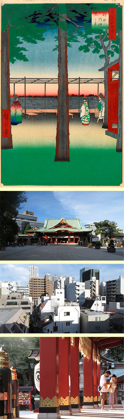
The 010 ”Dawn at the Kanda Myojin Shrine” is a picture of the rising sun from the precincts of Kanda Myojin. The place where this Kanda Myojin is located is on the edge of the Hongo plateau and was open to the east, so it seems that it was an observatory overlooking the entire city of Edo along with Mt. Atago of Shiba.
First, let's check the location from the old map. I put a red gradation in the place to be the viewpoint. The light blue line that crosses left and right is the Kanda River. I overlaid a modern map on this. Actually, it was around New Year's Day, so if you look at the first sunrise of the year, it seems that the direction of the viewpoint was a little further south.
Let's actually look at the main part of the picture. In the precincts of Kanda Myojin, the priest on the left, the shrine maiden on the right, and the Jicho (shrine staff) seem to be watching the rising sun over the streets of Shitaya. From the wooden barrel held by Jicho called this sword, it is said that this is a scene of the Wakamizu fetching ceremony held on the morning of New Year's Day and New Year's Day.
In fact, until the Meiji era, Kanda Myojin seemed to be surrounded by more trees, and it is speculated that Hiroshige thinned out the trees a little and drew them according to the image of the picture he had envisioned.
First, I visited Kanda Myojin. This is the gorgeous Shinto gate that enters Kanda Myojin.
When you turn around, you can see the torii gate, and the wall and greenery behind it becomes Yushima Seido. To the right of the torii is Amanoya, which is famous for amazake made in the basement.
This is the current Kanda Myo Shrine. On New Year's Day, general worshipers will be crowded and crowded. From the beginning of work on the 4th, since he is also a god of business, worshipers from companies related to Tokyo will be added, and it will be very busy until the 10th.
Kanda Myojin is a popular name, and the official name is Kanda Shrine. A long time ago, it was said that the sea god was enshrined by a fisherman tribe who took the ocean current from Shikoku and settled on the Boso Peninsula. It seems that the beginning of this shrine was when its descendants moved to Edo and enshrined the sea deity.
The god is Awa Sunosaki Myojin in Sunosaki, southern Awa (currently Tateyama City, Chiba Prefecture), and its affiliated shrine is said to have been enshrined in Shibasaki Village, Toshima District (currently Otemachi). After that, when the tomb of Taira no Masakado in the neighborhood was called a disaster, a grudge, etc., around 1300, a monk named Shinkyo Shonin enshrined Taira no Masakado at this shrine, and the local god (Ubusunagami) It is said that it was made.
This is the head mound of Taira no Masakado in Otemachi. It is said that Kanda Myojin was around here before the move. Currently, it is under renovation until March 2021 due to the renovation work of Mitsui & Co., and it is not possible to enter inside.
When Ieyasu Tokugawa entered Edo, he used this shrine as a general guardian of Edo to make it popular with the indigenous people of Edo. After that, with the expansion of the city of Edo, I moved to the current location, which is the demon gate in the northeastern part of Edo Castle, via Surugadai. Furthermore, as the Tenka Matsuri of Edo, along with the Sanno Festival, it will develop as a support for the hearts of the townspeople.
In the middle of the Edo period, the god of Kanda Myojin was added with Oonamuchi no Mikoto (Daikoku-sama = god of marriage), which belongs to the agricultural god Amaterasu. Became one of the main deities. However, in the 7th year of the Meiji era, when Taira no Masakado was labeled as a rebel who turned to the imperial family and was transferred to the shrine, Sukuna Hikonanomikoto (Ebisu-sama = god of business prosperity) was replaced. I came in. Now, Kanda Myojin is in this three-god position.
However, it seems that Edokko (common people of Edo) did not think that Masakado was a rebel for a long time.
I actually went to this place. The building on the right is the Myojin Kaikan, and I imagined the shrine in the picture. The building is too tall to say that the view is good.
This photo was taken over the fence. It's just a view of the buildings in the direction of Akihabara.
Next, I turned the camera counterclockwise from the top of Otokozaka. The Myojin Kaikan, the shrine, the shrine and Kagura hall donated by Konosuke Matsushita (the founder of Panasonic), the qualia mansion, and so on. The big building in front is the Fujisoft building at the east exit of Akihabara.
By the way, this time, I tried to fit Hiroshige's picture by adjusting the color of the actual current scenery to match the picture like in the morning.
The painting of Hyakukei Edo has a mark at the time of publication called a reprint, but this painting is in September of the 4th year of Ansei (1857). September is the month of Kanda Matsuri. At the time of the Sanno Festival and the Kanda Festival, as the Tenka Matsuri of Edo, portable shrines, floats and dancers were allowed to enter the Edo Castle specially. However, in July of this year, the town was touched and they were banned altogether.
It seems that the cause was the damage caused by the big earthquake of Ansei in the previous year, the fiscal austerity policy of the Edo Shogunate that had continued since before, and political instability caused by the arrival of foreign ships. Considering this, Hiroshige seems to have drawn this picture in hopes of the reconstruction of the gorgeous town of Edo as before. The dawn of Kanda Myojin and the fetching of young water on New Year's Day, which were loved by the common people of Edo, are exactly the rebirth of the town.
